Category:Arvine Heights Historic District
Jump to navigation
Jump to search
Main Wikipedia article: Arvine Heights Historic District.
| Object location | | View all coordinates using: OpenStreetMap |
|---|

|
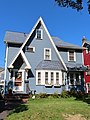
This is a category about a place or building that is listed on the National Register of Historic Places in the United States of America. Its reference number is 15000310. |
United States historic place  | |||||
| Upload media | |||||
| Instance of | |||||
|---|---|---|---|---|---|
| Location | Rochester, Monroe County, New York | ||||
| Street address |
| ||||
| Heritage designation |
| ||||
| Area |
| ||||
 | |||||
Media in category "Arvine Heights Historic District"
The following 4 files are in this category, out of 4 total.
-
 48-52ArvineHeights.jpg 5,184 × 3,888; 8.82 MB
-
 58ArvineHeights.jpg 3,888 × 5,184; 7.87 MB
-
 64ArvineHeights.jpg 3,888 × 5,184; 7.9 MB
-
 95ArvineHeights.jpg 3,888 × 5,184; 10.51 MB


